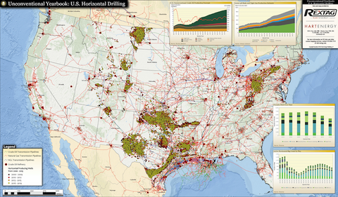
Crude Oil Pipeline System Digital GIS Data - North America
Comprising the 48 states of the United States continental mainland, Canada and Mexico, the Crude Oil Pipeline System Digital GIS Data is the most affordable GIS digital data in the market. And yet, the pricing does not compromise the quality of data.
The data set was designed to meet our very own high standards, which are based on customer satisfaction. Furthermore, our different licensing programs, allow our clients to customize their final data product.
All our U.S. Crude Oil Pipeline Systems include the following information:
- More than362 different crude oil pipeline systems
- More than 115,000 Miles of Pipelines
- Pipeline System Common Naming (i.e. ConocoPhillips, BP, etc)
- Crude Oil Refineries with Capacities(in BPD)
- Crude and Product Terminals
- Oil and Gas Fields
- Oil and Gas Basins
In addition, Hart Energy knows about budget constraints confronting small and medium size companies. Therefore, we have created a great licensing program. Our customers can get our GIS Data for the areas they are most interested, or buy the whole set with our system of price breaks:
- Gulf Crude Oil Pipeline System Digital GIS Data
- East Crude Oil Pipeline System Digital GIS Data
- West Crude Oil Pipeline System Digital GIS Data
- Canada Crude Oil Pipeline System Digital GIS Data
- Mexico Crude Oil Pipeline System Digital GIS Data